
Mapping

NSGC - Resource
The Nova Scotia Geomatics Centre (NSGC) has been an on-going client of GeoNet for over 18 years. GeoNet has extensive experience working with the Province of Nova Scotia and its NS Topographic Database. Most recently, GeoNet has been involved in updating and editing the 1:10k provincial topographic mapping database.
GeoNet uses our high precision DAT/EM Summit Evolution softcopy software, integrated with ArcGIS, to perform data compilation. The stereo model seamlessly activates adjacent models to allow for efficient collection. Data collection is performed to a high standard of accuracy to produce highly accurate 3D shape files representative of the true position of topographic and man-made features.
Following data collection, digitized features undergo a rigorous Quality Control process that ensures consistency between delivered products. The Quality Control process addresses, among many other issues, clean line data, co-location of segments, and the consistency of line nodes. This process is performed on each sheet before being delivered, and before its use in the creation of ortho-rectified mosaics for each sheet. Our resulting topographic map sheets are of a high standard, and hundreds of sheets have been completed to date.

NSGC – Watershed Toponymic & Network Upgrading
The Nova Scotia Geomatic Centre (NSGC) worked with GeoNet to integrate the names of Nova Scotia Toponymic Object water based features (rivers, lakes, coves, etc.) into the Nova Scotia Hydrographic Network dataset. Hydrographic networks were constructed and extensive Quality Control procedures were followed to ensure topological integrity within datasets.

Assessment of the Risk to PEI’s Coastal Residences, Infrastructure & Heritage from a Changing Climate
This UPEI-led and NRCAN-sponsored project entailed identifying vulnerable infrastructure along the coastline of PEI. GeoNet was tasked with mapping all vulnerable structures in flood-prone zones and modeling prospective coastlines 30, 60, and 90 years into the future.

PEI Multi-Town Urban Mapping
In 2019, the Towns of Stratford, Montague, Kensington and Cornwall, and the City of Summerside undertook a collaborative project to acquire a set of digital orthophotos from aerial photography. The group of towns wanted to utilize that imagery to produce vector map features that would be installed as part of their internal Geographic Information Systems.
GeoNet utilized our softcopy photogrammetric workstations to produce highly accurate 3D shape files representative of the true position of topographic and man-made features within the boundaries of each participating town. GeoNet technicians utilized their extensive experience in working with the Province of Nova Scotia for its NS Topographic Database, and adhered to strict standards for data collection. The result is a high-quality product that meets the standard of collection in the region.
GeoNet technicians performed thorough Quality Control checks to ensure that the resulting vector map features met appropriate standards.
The completed features provided an up-to-date and positionally accurate portrayal of the municipality’s topographic and aboveground man-made features and assets.
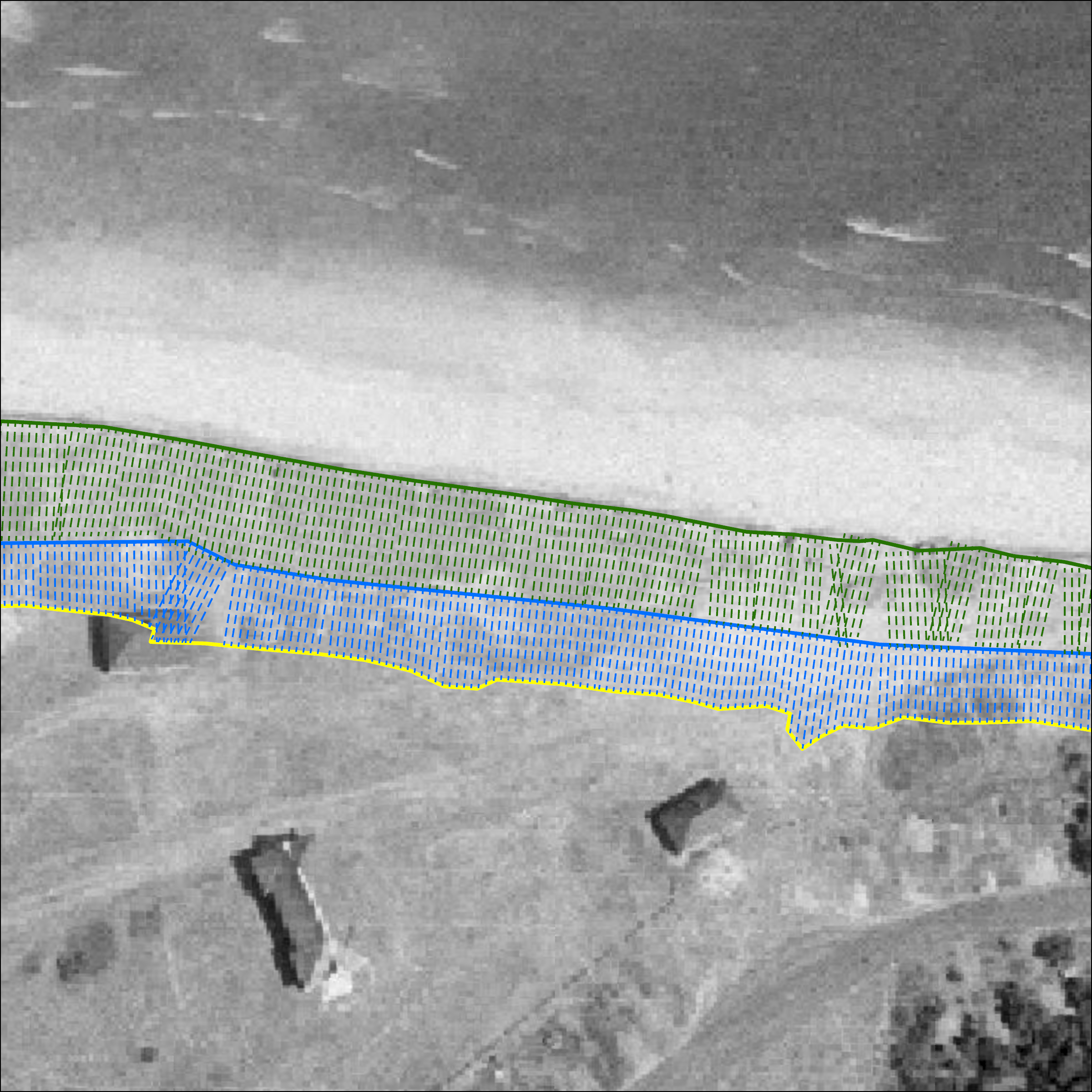
PEI Department of Environment - Coastline Change Analysis
GeoNet utilized orthophotos from 1968, 2000, and 2010 to delineate PEI’s coastline and analyze coastline change rates from 1968 to 2010, and from 2000 to 2010. A set of temporal coastlines segmented based on erosion rates was derived by comparing the coastline position at one date to its previous position. These resulting datasets provided the client with a coastline changes rate for every meter of PEI’s coastline. This data is utilized by the Department of Environment Labour & Justice when determining setbacks for granting building permits.

CITY of Moncton - Historical Orthophotos
In this project, GeoNet geo-referenced and created mosaics of hundreds of historical scanned photographs ranging in time period from the 1950s to the 1990s for the City of Moncton. Technicians used roads, buildings, and other datasets to collect ground control points for the orthorectification process. GeoNet delivered both the individual rectified images and mosaics for each year.